Incident
As many of you will know, on Sunday 8th one of our members was seriously injured on the South face of Parlick and airlifted to hospital. We wish him a full and speedy recovery from his injuries.
As we move towards winter, it’s worth analysing in some detail how the weather may have been a significant factor. As the power of the sun to heat the ground reduces, thermal production slows and so the mixing of the layers of air stops happening and a low-level inversion can often last all day. You will often see clouds above whizzing past with little or no wind on the ground early in the day. In summer, vertical mixing of the upper and lower layers usually clears this inversion, but in winter it can lurk undetected. If this layer is below the take off, you may feel this as a sudden increase in wind speed from very light to very strong, possibly with an abrupt change in direction – a clear warning sign. However if the layer is just above take off, you may launch from what feels like a perfect breeze into a nightmare as the friction between the layers of air moving at different speeds and directions creates violent vortices. This can happen at any altitude, but if it’s close to the ground, any collapses induced may be unrecoverable before impact.
Warm southerly airflows are particularly prone to causing this effect as they produce more pronounced inversions, which is significant for our south-facing sites like Parlick and Nonts. An approaching warm front can mean warm air riding over the cooler air near the ground, which exaggerates the inversion Add in the wave influence of upwind hills (Longridge, Standedge) and you get a recipe for extreme turbulence, just where you don’t want it.
Back in the day, we used to just have the TV forecasts and shipping forecasts, so just went out when the weather man (and it was always a man back then) said the magic words ‘light to moderate’ and sometimes had a horrible experience, muttering over our beers about what might have caused it. Now we have incredibly detailed atmospheric models to predict what the wind is going to be doing at every level. The question is how to access and make use of this amazing resource. The ground level wind speeds on the Met Office site, XCWeather etc are only a starting point – if they say too strong, then it’s too strong, but if the numbers are low, it’s vital to look at the upper layers to get an idea of what is going on above our heads. This isn’t the place for an in-depth lesson on weather forecasting, and I’m not the person to do it, but here’s a few take-aways from the conditions on Sunday.
This is the RASP tephigram custom sounding for 1100 BST on Sunday 8th October for Chipping (CHP) Note the low level inversion where the air temperature increases with height and how the wind changes direction .
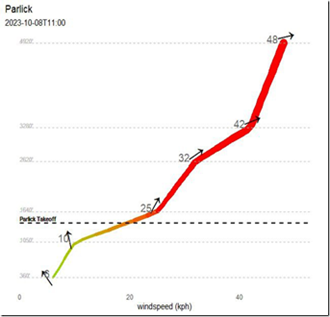
Here’s another view of the 1100 data, provided by NOAA and analysed by Neil Charles:
Here we can see that the wind was forecast light SE at ground level, fresh S at take off and veering to strong SW just above.
Other sources of data include Windy.com and the Windy.app, Ventusky, which have free versions that provide this data. There are many others. My advice is to find one that you can learn how to use, and visit it regularly before flying. Look at them on the days before too, see how the forecasts change. Where possible examine the different data sources (ECMWF, Met Office, NOAA, GFS etc.) – the more they agree, the more confidence you can place in the prediction.
So how do we use these data in order to make out flying safer?
We are the pilots, and we are responsible for our own decisions; there is no launch marshal or air traffic controller to make us see sense. Here are some tips:
ALWAYS check winds at higher altitudes – all year round. Don't just look at ground level winds before flying. We don't fly at ground level, so it is silly to only look at ground level winds. Even on days when there is no inversion there can often be surprisingly stronger winds at take off height or higher.
In summer you will mostly get away with only looking at ground level winds, as in summer the difference between ground and upper winds is generally not great for the reasons given above. But why not spend five minutes looking, it may save you a wasted trip to a blown out hill.
In winter you won't get away with only checking ground level winds for long. Even on days when there is little or no inversion, the difference in winter between ground level and higher level winds can be dangerously high. Add an inversion around hill hight and danger is multiplied.
The wind speed and directions on soundings can be a little awkward and imprecise to read; however using websites like www.ventusky.com you can check the wind speed and direction of all northern England at 10m, 100m, 250m, 500m, 750m, 1000m, 1500m etc. You don't have to check every altitude, but you should check 100m, 500m (take off altitude) and 750m at say 10am, 1pm and 16pm. When you get familiar with a website or app like Ventusky you will be able to check the winds in five minutes. It is a lot quicker than recovering in a hospital bed for four months.
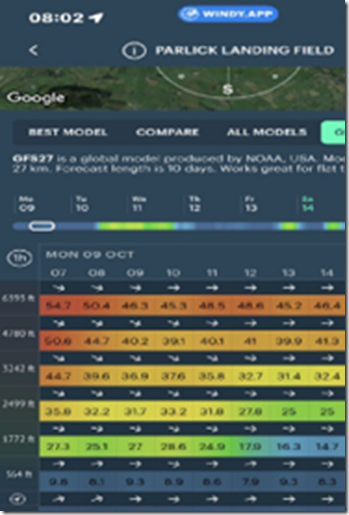
Using the free version of an app like Windy.app you can get a spot forecast for Parlick landing field showing the wind at all altitudes in about 60 seconds, as below:
Neil Charles is currently developing a tool to show graphically the wind speed and direction at our sites and elsewhere. Watch this space for news
Don't use RASP for wind speed in winter. In summer time the RASP parameters “BL Avg. Wind” and “Wind at BL Top” are excellent forecasts. But in winter these parameters are often useless as the Boundary Layer is so low. If there is an inversion at 900ft then BL top will be 900ft, so “BL Avg. wind” will be an average of the wind from the ground level to 900ft – not much use when you are taking off at 1300ft.The decision to take off is every pilots personal responsibility, every pilot should be checking the weather before they fly. Don't rely on others, don't fly like sheep!
Brian Stewart and Phil Wallbank, with contributions from Gordon Rigg (DSC).
![clip_image003[11] clip_image003[11]](/media/articulate/open-live-writer-safety-notes-october-2023_f1ad-clip_image003-11-_thumb.png)

